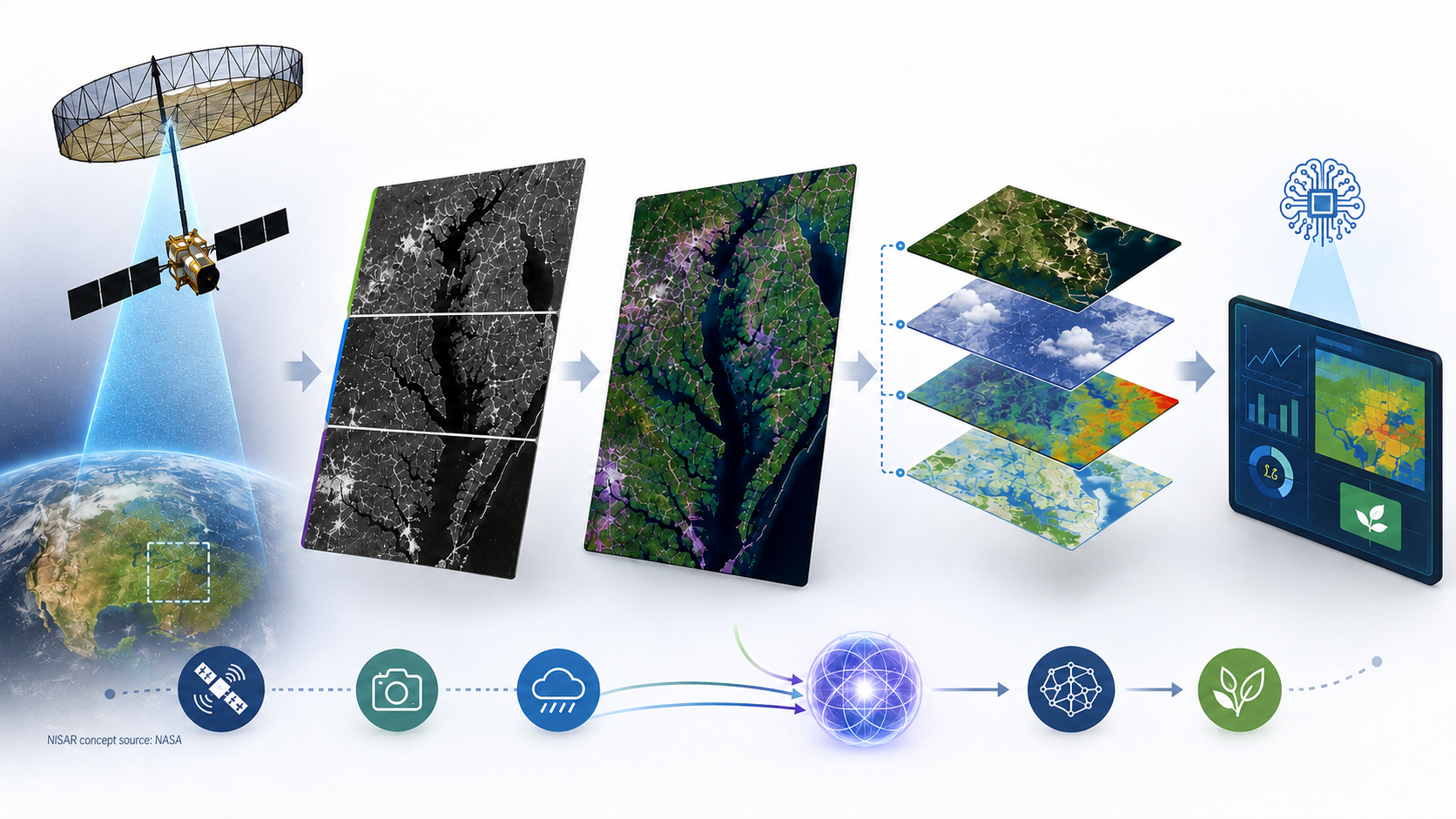
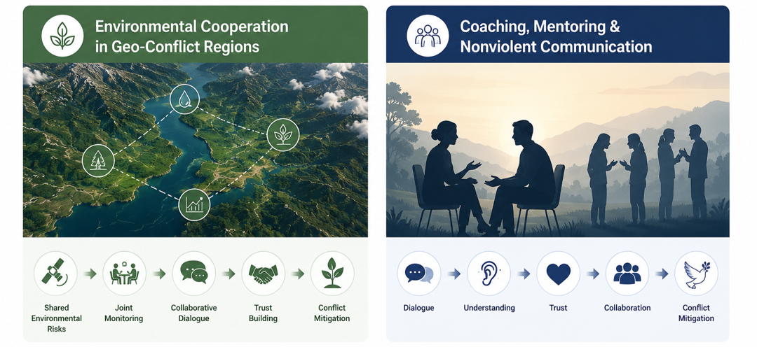
GEBA Consulting LLC

GeoAI for Agricultural & Environmental Intelligence

Transforming Earth observation, environmental data, and AI into practical decision-support solutions for sustainable agriculture, environmental monitoring, integrated modeling, and conflict mitigation.

Food Security & Precision Agriculture

Sustainable Agriculture

GeoAI-enabled crop monitoring, in-year yield forecasting, crop and vegetation biomass estimation, and precision agriculture applications using Earth observation and environmental data.


Precision agriculture example for revealing spatial variability and supporting field-specific agricultural management. Related paper ✎

Precision Agriculture
Crop yield prediction maps
Crop yield prediction from local field examples to regional and national monitoring
In-Year forecasting of crop yield several months before harvest
Adaptive AI modeling across crops, eco-regions, and environmental conditions
Decision support for precision management, production outlooks, commodity-market planning, and food-security monitoring
Disease Risk, Biodiversity & Ecosystem Intelligence

Environmental Monitoring

Environmental intelligence systems for disease risk mapping, biodiversity monitoring, and ecosystem analysis. Related paper ✎

Tick-borne disease risk maps
Disease-risk mapping, forecasting, and early-warning systems
Biodiversity and ecological hotspot mapping
Environmental driver analysis using explainable AI
Climate-sensitive risk assessment and monitoring
Explainable, Adaptive & Scientific AI

Multifaceted AI

Development of interpretable and adaptive AI systems for Earth observation, environmental analytics, and data-driven decision-making.

Advanced machine learning and deep learning modeling for geospatial and environmental applications
Explainable AI using SHAP, feature contribution analysis, and interpretable model diagnostics
NLP/LLM-based trend analysis, and network analysis for extracting knowledge from historical and textual data
AI-Powered Geospatial Mapping App for Decision Support
SAR, Optical, Climate & Environmental Data Fusion

Multisensor Integration & Interoperability

Leveraging complementary Earth observation systems to improve environmental intelligence through multisensor interoperability. Related paper ✎ GEE APP 🗺️

SAR–Optical interoperability
Multi-frequency satellite integration
Cross-sensor consistency assessment
Operational Agricultural and Environmental Monitoring
Environmental Cooperation + Human-Centered Communication

Dialogue, Trust & Conflict Mitigation

Creating shared grounds for dialogue through environmental cooperation, coaching, mentoring, and Nonviolent Communication.

Environmental Cooperation in Geo-Conflict Regions

Using Earth observation, environmental intelligence, and ecological risk assessment to identify shared environmental challenges and opportunities for collaboration in geopolitically sensitive regions. Related paper ✎

Coaching, Mentoring & Nonviolent Communication

Supporting individuals, leaders, families, and organizations through coaching, mentoring, and Nonviolent Communication practices that strengthen trust, empathy, and constructive dialogue.

Dialogue, trust, and conflict mitigation
Shared environmental risk assessment
Collaborative dialogue and trust-building
Conflict coaching and leadership mentoring
Nonviolent Communication and relationship development
Who We Are

About & Contact

Geo-Informatics Environment & Agriculture Bridging AI (GEBA) Consulting LLC develops practical GeoAI solutions that transform Earth observation data into actionable intelligence for agriculture, environmental monitoring, sustainability, and collaborative decision-making.

Project, Business & Coaching Inquiries

We welcome inquiries for GeoAI consulting, crop yield prediction, biomass estimation, biodiversity monitoring, disease-risk mapping, environmental intelligence, integrated modeling, collaborative projects, educational opportunities, and personal, organizational, and cross-cultural coaching for conflict mitigation.

Email: info@gebaconsulting.com

Website: gebaconsulting.com

Location: Vienna, Virginia, USA

You may also leave a message for project inquiries, collaboration ideas, coaching requests, or general questions. Your full message will be sent privately to GEBA, while only a masked name and category may appear on the public message list.

Leave a Message →

Founder

Geba Chang

Dr. Geba is a multidisciplinary expert with more than 20 years of experience across electrical engineering, environmental engineering, remote sensing, GeoAI, and data science. His work focuses on developing practical geospatial intelligence for agricultural and environmental applications.

His recent work has been recognized with the GeoGov Award – Innovation in Geospatial Research for advancing SAR–optical interoperability and improving the reliability of Earth observation for agricultural monitoring.

Co-Founder

Renah Kim

Mrs. Renah is a doctoral researcher whose work centers on intercultural engagement, relationship-centered communication, and human development. Drawing from extensive international and cross-cultural experience, she supports individuals, leaders, families, and organizations through coaching, mentoring, and Nonviolent Communication.

Her approach emphasizes empathy, trust-building, constructive dialogue, and collaborative problem solving across personal, organizational, and multicultural contexts.

GeoGov Summit award

GeoGov Award – Innovation in Geospatial Research

Dr. Geba was recognized for addressing a long-standing challenge in agricultural monitoring: how rainfall distorts radar signals and affects vegetation mapping accuracy.

The work developed a practical framework to understand and correct precipitation effects on SAR-based vegetation indicators, improving SAR–optical interoperability and strengthening reliable Earth observation for agricultural monitoring and food-security applications.

GEBA AI Assistant
Hello. How can GEBA assist you today?